

Localizado en la zona central de la cordillera volcánica guatemalteca, el volcán de Fuego es uno de los cuatro volcanes activos del país. A lo largo de los años el volcán ha mantenido una constante actividad con emanaciones de lava y explosiones que arrojan materiales a alturas superiores a los 5,000 msnm. Sin embargo, la mañana del domingo 3 de junio la actividad del volcán de Fuego tuvo un incremento considerable. Esta actividad se mantuvo en incremento hasta que, al filo del mediodía, una poderosa erupción provocó una de las mayores tragedias de la historia reciente de nuestro país. De acuerdo con las cifras oficiales, 113 personas murieron a causa del flujo piroclástico que depositó más de 12 millones de metros cúbicos de material volcánico en la cara sureste de las faldas del volcán. Consecuencia de ellos, también se estima que más de 300 personas quedaron soterradas bajo el material, principalmente en la comunidad de San Miguel Los Lotes localizada en el municipio de Escuintla, en el sur de Guatemala.
Durante los momentos posteriores a la tragedia, se vivió un ambiente de incertidumbre debido a que las autoridades no tenían la capacidad de dimensionar la magnitud de la catástrofe a la vez que la información desde el lugar fluía de forma lenta. Así mismo, las entidades encargadas de dar respuesta se encontraban bajo un panorama de incertidumbre ya que la actividad eruptiva del volcán se mantenía constante por lo que acceder a la denominada “zona cero” era prácticamente imposible. En adición, las altas temperaturas del material depositado impedían el acceso a los lugares donde el impacto de la erupción había sido mayor.
La noche del domingo, conmovidos por la tragedia, el equipo de Aerobots programó un vuelo de sus aeronaves autónomas con el fin de hacer un levantamiento fotográfico de la zona afectada por la erupción; se coordinó apoyo con el ingenio Pantaleón para disponer de su pista de aterrizaje. El lunes 4 de junio a primera hora, el área de operaciones de la empresa mandó dos aeronaves autónomas desde la pista del ingenio, localizada a más de 20 kilómetros de la zona cero (figura 1). Previo al despegue, se coordinó con la Dirección de Aeronáutica Civil de Guatemala (DGAC) el sobrevuelo del área, puesto que las regulaciones de vuelo de aeronaves autónomas requieren de dicha coordinación con las torres de control encargadas de los espacios aéreos. Debido a que en el lugar se encontraban volando helicópteros de rescate, se coordinó asignar espacios aéreos de manera que no se pusieran en riesgo ninguna de las aeronaves, tanto tripuladas como no tripuladas. Se le asignó a Aerobots el espacio aéreo de la zona cero por encima de los 600 metros sobre el nivel del suelo, mientras que las naves de rescate por debajo de esa altura. Aerobots se encargó de la toma de fotografía aérea y la toma de video 360 de la zona afectada. Más de 2,500 hectáreas de fotografía aérea fueron cubiertas en poco más de una hora de vuelo.

Figura 1: Equipo de operaciones de vuelo de Aerobots y personal de apoyo del área de ingeniería agrícola del Ingenio Pantaleón.

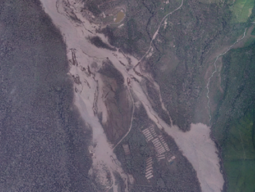
Figura 2: Ortomosaico generado de la zona cero (0.30 m/pixel) el día 4 de junio de 2018. En la imagen se observan las deposiciones de material volcánico sobre el club de golf La Reunión (parte superior) y San Miguel Los Lotes (parte inferior).
La información fue enviada a servidores de la empresa en Guatemala y poco después del mediodía fue generado un ortomosaico de una resolución espacial de 0.30 m/pixel (figura 2) y un modelo de elevación digital de una resolución espacial de 1.00 m/pixel (figura 3); dicha información fue la primera en ser generada debido a que las condiciones meteorológicas (alta nubosidad) y las partículas volcánicas suspendidas en el aire, impedían que satélites pudieran obtener imágenes del volcán. Los dos productos generados fueron entregados a entidades encargadas de respuesta ante el desastre como la Coordinadora Nacional para la Reducción de Desastres (CONRED), entidades encargadas de generar información como el Instituto Nacional de Sismología, Vulcanología, Meteorología e Hidrología (INSIVUMEH), y entidades de carácter académico y científico. Al día siguiente la información se liberó en nuestros servidores para que estuviera disponible a todos los interesados de diversos sectores del país y con eso sumar esfuerzos de respuesta ante la tragedia. La fotografía aérea fue utilizada como base de información para la generación de cartografía preliminar de las áreas pobladas afectadas, y el modelo de elevación digital fue utilizado para generar curvas a nivel y para la cuantificación del volumen de material depositado en el área afectada.

Figura 3: Modelo de elevación digital (1.00 m/pixel) el día 4 de junio de 2018. En la imagen se observan las curvas a nivel cada 10 metros sobre la zona cero. La paleta de colores indica mayor altitud sobre el nivel del mar en los colores rojizos y menor en los colores verdes.
La libre distribución del ortomosaico y el modelo de elevación digital hizo que los productos llegaran a manos de guatemaltecos en entidades en el extranjero, como la NASA o la Universidad Tecnológica de Michigan, donde expertos en ciencias de la Tierra analizaron la información y la pusieron a disposición de la comunidad científica del mundo a través de diferentes portales. De la misma manera, tanto el sector público como el privado de Guatemala unieron esfuerzos desde diversos entes para utilizar los productos y generar nueva información que fue puesta a disposición de entidades encargadas de la respuesta, el análisis y la formulación de estrategias para reducir el riesgo de desastres.
Comments are closed